The last week of April saw the arrival of this year’s Windom High School group from southwest Minnesota, consisting of nine enthusiastic, weather-savvy seniors, their teacher, Craig Wolter, and three chaperones. Each year, Craig takes his top ten or so students on a five-day storm chasing trip to Norman, where the students get to visit the NWC and meet and greet with meteorologists there. Craig has a tight itinerary for his students upon arriving in Norman, but it can always be pre-empted by a decent chase setup. As a fellow Minnesotan, I have a soft spot for Craig’s kids, and always try to lead them on at least one chase. If there had been such a program at my high school, I would have killed to get on the trip!
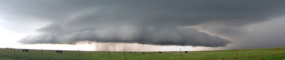
The Claude, TX LP supercell, around 6 p.m. The view is toward the west. Dan and I were able to take Windom group out on Monday, April 30th, after noticing an enticing setup in the Texas panhandle consisting of a trough encroaching on an outflow boundary from the previous night’s widespread convection. Upon arriving in Memphis, TX, we found convection struggling to initiate along the dryline. We drifted northwest on U.S. Hwy. 287, toward a clump of storms west of Amarillo, intercepting it as it organized into a supercell near Claude, TX. We drove about 2 miles north off of U.S. Hwy. 287 to obtain a clear view to the west.
This "nipple cloud" (just left of the rain shaft) persisted for about three minutes and prompted several funnel cloud reports. We think it would have developed into a full tornado if the storm had been able to tap into deeper moisture just to its east.We were presented with a beautiful, high-contrast LP supercell, and proceeded to point out all the salient features to the students. The high bases didn’t bother us too much, because we knew the Claude storm was drifting east into better moisture, and we expected great things from it once it began to realize the improved buoyancy. As we watched, the Claude storm split right in front of the students, allowing us to narrate the process live. I pointed out a small, cone-shaped lowering just south of the main precipitation shaft on the right-mover. It persisted for three to four minutes, but never extended more than 10% of the distance from cloud to ground.
Windom HS students watching the approaching base of the Claude, TX supercell.Meanwhile, we noticed new Cbs to our east, rooted in the deeper moisture. The updrafts on the new towers were crisp and glaciated, so we kept our heads on swivels in case we needed to re-target. The Claude storm dropped a few nickel-and-dime hailstones on us, forcing us to jog east twice along our dirt road in order to keep ahead of the storm. The vault structure grew breathtaking. We were able to enjoy it in relative solitude, without any other chasers blowing clouds of dirt on us. Simply moving a mile or so off the main highway is proving a surprisingly effective way to avoid the hordes. (I think I’m going to require 4WD in my next chase vehicle.)
The Claude, TX supercell eventually became outflow-dominant, so we decided to re-target the next storm to the east (the Hedley, TX storm), whose birth we had witnessed about an hour before. We retraced our route southeast on U.S. Hwy. 287, then went east on TX-203. We thought we would be able to core-punch the Hedley storm without too much trouble as it lifted northeast, then emerge from its forward flank and with a view of the hook to our southwest. However, radar updates showed new storm cells erupting to the south of, then being ingested by, the Hedley storm. These processes interfered with storm consolidation and hook formation, and also resulted in our spending more time in the hail core than we expected, our vehicles pelted with nickels and dimes for nearly 40 minutes.
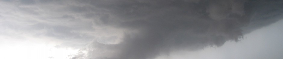
At dusk near Wellington, TX: Gustnado? Tornado? The view is toward the SW, the feature of interest at the center of the image.When we finally did emerge from what should have been the forward flank of our target storm, crossing over the border where TX-203 changed to OK-9, it was dusk. Looking back toward Wellington, TX, we caught glimpses of the hook region to our southwest. Suddenly, Dan commanded me to stop the car, chattering excitedly about a dust cloud. I couldn’t see anything from the driver’s seat, but I stopped at the top of a hill. By the time I got out of the car and fired up my camera, the dust cloud was gone, but I could see the scud finger which had grabbed his attention. My only photo of it is very poor and I had to enhance the hell out of the contrast in order to make it visible. The feature was too brief and ambiguous, the distance too far, and the lighting too poor, for us to conclusively call it a tornado.
We took a rather circuitous route back to Norman via Lawton, attempting to avoid a southward-diving hailer over Hobart, OK. We returned to Norman around 1 a.m.
In the days since this chase, I’ve read an April 30 chase account from Bill Reid, whose Tempest Tour group (including Brian Morganti) was much closer to the ambiguous lowering than we were. Even with his close proximity, he wasn’t certain what to call the feature, and after viewing his video, I can see why. However, he eventually concluded that this dusty spin-up was indeed a tornado. Bill’s a veteran chaser, and if he says it was a tornado, then that’s good enough for me. Based on his account, I was able to report to Craig that his students were no longer tornado virgins!
SPC 1630 UTC Day 1 Convective Outlook on 27 April 2012. Copyright NOAA.Parental visits in springtime are always fraught with uncertainty. We can pack our agenda for the weekend with varied activities, only to have everything unravel the minute the atmosphere starts acting up. I had poo-poohed the chase setup for Friday, April 27th, thinking that it wouldn’t be worth driving to Kansas. However, I awoke to find the forums abuzz with excitement about the shortwave trough ejecting earlier than forecast, prompting a moderate risk on the Day 1 convective outlook from SPC. Anticipating an early afternoon chase setup, my husband and I scooped my parents up from the airport, and blasted north on I-35 into south-central Kansas, where we were greeted by clearing skies and a few turkey towers along the dryline. (Mom and Dad had flown more than 800 miles south from Minnesota to see us, only to backtrack immediately almost 1/3 of the way home.)
Brief funnel cloud near Council Grove, KS. Note the clear slot illuminating the funnel.Near Emporia, KS, we met up with Jeff S., chasing solo. The atmosphere produced mediocre convection for hours. As a surface low approached from the west, increasing the low-level shear, it also squeezed the warm sector between the cold and warm fronts. We were forced to follow the warm air up into the Flint Hills area. This region has good visibility, provided that you’re on top of one of the hills. By the time we targeted a storm near Council Grove, KS, the warm sector (and the storm’s access to the warm, moist air within) was only a few tens of miles wide, if that. Cold rain and gusts of wind pelted us as we parked on a hilltop gravel road off U.S. Hwy. 56 near Bushong, KS, watching two cloud bases to our west-northwest. Suddenly, Jeff S. shouted to our group as a small white funnel abruptly materialized within an RFD slot to our northwest. I barely had time to re-center my video before it eroded away.
Brief tornado near Council Grove, KS. One or two suction vortices revolved around the base.Minutes later, another funnel descended from the far bank of clouds, tickling the ground with a few suction vorticies. From my vantage point, this brief tornado dropped right behind a tree. My video consists mainly of my scrambling a few feet to the right and re-leveling my shot, by which time the tornado had already vanished. Because of the brevity of these two funnels and the shakiness of my video, I decided not to post either shot on YouTube. Screen shots it shall be.
The cold rain and pea-sized hail began to fall in earnest, driving us back into our cars. We may have glimpsed another funnel on the horizon, but lost it in the rain after a few seconds. To our north was a road hole, forcing us to head east on U.S. Hwy. 56. The remainder of our chase consisted of an attempt to catch another storm to the east of our original target. Unfortunately, it was ingesting stable air, the warm sector long since squeezed out of existence, and we decided to abandon the chase near Osage City, KS. We had dinner at Emporia, then began the long haul back to Norman.
As I’ve gotten older, I’ve gotten little more choosy about which days I chase. (I chalk part of this change up to accumulated experience, and part to having a full-time job and family to support now that I’m done with school.) However, when I have guests along, I’m more likely to bite on riskier setups with more potential failure modes. Even though it required a 5-hour drive each way, seeing one tornado is definitely better than seeing none!
Today, I broke my personal record for the number of tornadoes seen in a single day (9, 10, or 11). Two were small funnels near Freedom, OK; the remainder were produced by a single supercell that we followed from Mooreland to Manchester, OK.
SPC 1630 UTC Day 1 Convective Outlook on 14 April 2012. Copyright NOAA.I had some trepidation heading out on 14 April because it was a widely-publicized SPC high risk on a Saturday. I had no wish to re-experience the Kingfisher, OK Charlie Foxtrot of 19 May 2010 (when it seemed like every storm chaser on the Great Plains converged on one two-lane highway, with a solid line of cars from horizon to horizon – not even joking). However, the moderate risk area stretched from the Missouri River to the Red River, encompassing Nebraska, Kansas, and most of Oklahoma, so I figured the atmospheric playground would be big enough to handle the chaser convergence. We decided to target the Oklahoma portion of the high risk, where the moisture was better and supercell shear was forecast. With the storm motions progged to be 35 mph or faster, our strategy was to follow tail-end Charlie storms until they raced northeast out of our reach, then turn back southwest to catch the next in line.
Our mini-caravan consisted of two cars: Jeff S., Howie B., and John L. in the first, while I drove Dan D. and Michael H. in the second. We departed Norman just after noon and drove up the Northwest Passage. From Seiling, we headed north on U.S. Hwy. 281, then west on U.S. Hwy. 412 after the first tail-end Charlie storm. Near Freedom, OK, we caught a glimpse of a slender needle funnel as we crossed the OK-50 bridge over the Cimarron River around 4:30 p.m. About 10 minutes later, just east of Freedom, it again produced a slender needle, both of which we captured on video. We were a bit disappointed at the brevity of both tornadoes; neither lasted more than 30 s. Knowing that a new storm was forming down the line, we decided to end round #1 and head back southwest toward Woodward.
Back on U.S. Hwy. 412, we stopped about halfway between Moreland and Woodward. A second supercell with a vigorously rotating wall cloud churned past us just a few miles to our west, but did not produce any funnels. We followed that storm east along 412 almost to the intersection with U.S. Hwy. 281, where we decided to head south a mile or so and find an unobstructed view towards the next storm erupting back to our southwest. We staked out a claim on a pull-off near the top of a hill, and waited. Several other chasers joined us there.
2012-04-14: Woodward Co., OK tornado around 7:00 p.m. The view is toward the west.Around 7:00 p.m., excitement began to build as the target storm grew near and a fat funnel descended about 10 mi to our west, playfully twirling a cloud of dirt at its base. That tornado had a lengthy (<15 min) rope-out phase as we trained our cameras on a new mesocyclone to its east, which also dropped a truncated funnel halfway to the ground to our NNW. We were elated to finally see some tornadoes with decent longevity and contrast, and we couldn't tear ourselves away. By the time we finally did pile back into our vehicles and headed back north on 281, yet another new meso was taking shape directly to our north. With the storm scurrying away toward the northeast, we were considerably behind it for the remainder of the chase.
The new lowering narrowed almost to a square. The lower portion then tapered into an unequivocal funnel, and tornado #5 was born. Returning to the U.S. 412/281 intersection, we found that 281 northbound toward Waynoka was blocked by two police cruisers, forcing us to turn east. The chaser crowds had by then thickened considerably, and I focused my eyes on the eastbound shoulder of U.S. Hwy. 412, only stealing occasional glimpses toward the north, where Tornado #5 was churning happily away. (I trust that my husband got HD video for me to enjoy later.)
At some point, we stopped to film again, and I witnessed a bizarre handoff between two tornadoes. (It occurs at about the 3:00 minute mark in the YouTube video above.) One vortex eroded as another descended right next to it. We can be heard disagreeing verbally about whether we were witnessing multiple vortices within the same tornado revolving around a common center, or two separate tornadoes doing a graceful dance. (Mobile radar data could have settled that question, but unfortunately, RaXPol was in the shop.)
We then drove up OK-8 towards Cherokee, OK, with tornadoes (sometimes multiple tornadoes) visible almost all the way there. On our approach to Cherokee at around 8 p.m., I shot my first-ever 3D footage of a tornado with my new Bloggie pocketcam, and was pleasantly surprised by how well it turned out. (I’ll review the camera later.)
Tornadoes continued to snake out of the storm as darkness descended. As the driver of my vehicle, I had to keep my eyes on the road rather than the tornadoes, and I didn’t particularly care about an accurate count. I was simply enjoying sharing the spectacle with my passengers.
Our chase was ended by downed power lines just after dusk, a few hundred feet north of the Kansas border near Manchester, OK. There was still an unmistakable, lightning-illuminated funnel visible to our northeast. That tornado later triggered a tornado emergency for Conway Springs, KS, southwest of Wichita, but thankfully dissipated before reaching town. We made our way back to Norman by way of Enid, OK.
After midnight, as we straggled back into Norman, word began to filter through that a tornado, spawned from a trailing line of storms, had ravaged parts of Woodward, OK. Woodward suffered greatly at the hands of an F-5 tornado in 1947, an event that still figures prominently in Oklahoma lore. Unfortunately, six fatalities resulted, and cleanup and recovery efforts are still ongoing as of this writing. Donations for the victims can be made to the American Red Cross.
Altus, OK was our initial target. As I merged onto I-44 W from Hwy. 9 with Dan D., Jana H., Jeff S., and Howie B., we saw a disorganized storm roiling over Chickasha, OK. Thinking little of it, we blew on past, targeting the a much better-looking storm down the line near Snyder, OK, and later, yet another storm west of Altus. As we approached Altus on U.S. Hwy. 62, our phones began beeping with robotexts from OU: “Emergency: Tornado approaching. Seek immediate shelter indoors.” Pulling up the radar, we saw that the storm we had blown off earlier had developed a healthy hook echo as it approached Blanchard, and tornado reports were popping up across Norman from credible Spotter Network witnesses.
Wall cloud over broccoli fields near Victory, OKPained to have missed a tornado at our home base, we instead intercepted our target storm near Victory, OK, just west of Altus. It struggled with outflow contamination from the morning’s convection, producing only a brief wall cloud over blooming broccoli fields. As it merged with another cell to its northeast, the complex began to transition into an HP supercell. Nothing prevents an HP supercell from producing tornadoes, but they tend to be difficult to see. We decided to let the Victory storm head on its merry way.
Howie Bluestein, storm chaserWe took another jog west to intercept a developing storm between Gould and Hollis, OK, that we thought would have access to uncontaminated inflow with better moisture. However, the Hollis storm didn’t look much better visually, and in the meantime, the earlier Victory storm had grown upscale and was leaving a trail of tornado reports in its wake. Most of the reports mentioned that the tornado was rain-wrapped – not optimal for visual documentation. We opted to stick to our target storm, hoping against hope that it would tap into better moisture and warmer temperatures to its south, staying a few miles east of it as it “chased” us back to Altus. It produced this ominous shelf cloud over Gould: Shelf cloud over Gould, OK on 13 April 2012
Daylight quickly faded, and we headed back to Norman just ahead of an MCS. I had forgotten to affix my new Pikepass sticker to my windshield, and the resulting 30-second delays while we aggregated quarters at each toll booth enabled the MCS to catch up, engulfing our car in blinding rain and dime-sized hail. Once back in Norman, we found large sections of town dark and surrounded by blinking Saf-T-Flares. The earlier tornado initially touched down near I-35 and Lindsey, then scraped northeast across downtown Norman, splitting trees, tossing sheet metal and demolishing a warehouse on Porter St. near the hospital. It was eventually rated EF-1 by the NWS.
Dan D., Jeff S., Mike F., and I headed west on 12 April 2012. SPC had issued probabilities for severe storms from the triple point in W KS down the dryline into the TX and OK panhandles. The discussion mentioned the conditional nature of the severe storm potential; i.e., if storms formed, then they would likely be severe and have a good chance at producing tornadoes.
We initially drove up the northwest passage. We had a shot at targeting the triple point, but opted for the dryline bulge target in TX instead, heading west out of Watonga. The entire drive, we were socked in by low-level cloud cover – not a good sign, since it would limit solar heating and limit the ability of updrafts to punch through the moderately strong cap. It was also relatively chilly for a chase day – temperatures did not rise out of the 60s for most of the day.
Cumulus patheticus south of Canadian, TX on 12 April 2012We set up shop in Canadian, TX, where the skies were clearing out, waited, waited, … and waited. Our eyes scanned the horizon for any sign of turkey towers. When one finally did erupt to our south around 7 p.m., we had nothing better to do, so we dropped south after it. A few bubbling cumulus clouds did develop, but none hit the tropopause, we ended up shower-chasing. We ended the chase in Elk City, where we enjoyed a decent supper at the Portobello Grill.
It was a high risk, high-reward situation, and unfortunately our numbers did not come up. In hindsight, at my own peril I opted to ignore a preponderance of model solutions that forecast a cap bust. As they say, however, if you don’t play, you can’t win.
I’d been anticipating this chase opportunity for nearly a week. In spite of that, my chase partners and I showed up late for the party. And in spite of that, we still witnessed a unique sight: a tornado interacting with the Wichita Mountains.
It’s fall in Oklahoma, and the jet stream is moseying back south. A couple of high-amplitude troughs have already swung low across the state, bringing chilly temperatures on brisk northwesterly winds. The long-range models were hinting at another such trough last week, but this one also brought surface moisture, ample deep-layer shear, and steepening mid-level lapse rates with it. There was no reason to hold back.
Our initial target was Altus. My chase partners (Dan, Jana, Jing) and I planned to leave Norman just after lunch. As usual, one thing after another delayed us by a few minutes at a time. Suddenly, somehow, it was 2:00 p.m., and supercells were already grinding across western Oklahoma. One near Frederick quickly dominated the others, all but flashing a neon “CHASE ME” sign. So, after far too much dawdling, we hastily piled into my car and blasted southwest along I-44.
During our haul southwest, our social media feeds lit up with quick pics of a fat, high-contrast cone near Tipton, OK. Earlier in my chase career, it was typical for me to arrive at a tornado-producing supercell, only to have it greet me by gusting out. Obviously, that still happens sometimes, and it’s always a kick in the wallet when a storm I’ve driven hundreds of miles to intercept mockingly turns to grunge in front of my eyes. Internally, I steeled myself for that possibility.
As we approached Lawton, Mt. Scott and the rest of the Wichita Mountains (actually some of the oldest mountains in North America, whose geologic history you can read about here) loomed against slate-gray rain curtains on the horizon. We were about 30 miles from a second tornado reported to be approaching Snyder, a town that had a prior abusive relationship with a tornado. We craned and strained but could not see any cloud base structure at so great a distance.
We debated our plan of attack. Heading west on U.S. Hwy 62 was not an option because the tornado had just crossed it at a 40 mph clip. Jana reminded us that OK-49, the next E-W highway to the north crossing the Wichita Mountains Wildlife Refuge, has a speed limit of 45 mph. Then we remembered the paved ribbon running west out of Elgin to Meers Restaurant, and took it. As we turned right past the cattle pens, promising ourselves a Meers burger some other time, Dan got a text message from Lou Wicker suggesting that we head northwest on OK-115 and intercept the storm near Saddle Mountain.
The mountains, of course, blocked our view of the cloud base for much of our approach. But all the signs aloft (updraft, clear slot) keyed our attention on a darkening shaft behind the scrubby ridges. My certainty of a rain-wrapped tornado surged we rolled up on it: Rain-wrapped tornado in the Wichita Mountains Wildlife Refuge (OK) at about 4:10 p.m. CST
We stopped shortly thereafter and caught the tornado crossing the inverted chins of stone comprising Saddle Mountain, and later passing in front of the wind farm just to its northeast. We observed it for about 15 minutes, repositioning once, and never saw another vehicle the entire time. Here’s my video.
Note that the trees on the hillsides are turning red – it really is autumn in Oklahoma!
I’d never witnessed a tornado interacting with complex terrain from such a short distance before, so observing its looping contortions was an unexpected treat. I also hadn’t gotten to watch a tornado in solitude for many a year. Apart from two news helicopters hovering behind us, my companions and I had the tornado all to ourselves. I kept expecting other cars to go zooming past, but the road behind us stayed curiously, almost eerily, vacant. We’re guessing the wildlife preserve forced many of the other chasers to divert around it to the west; very few came at it from the east. Sometimes, being late to the show has its advantages.
After the Wichita Mountains tornado was swallowed by a descending reflectivity core, we were hard pressed to catch up to it. We crossed the damage path (plastic bags, bits of sheet metal, and other miscellaneous trash caught in barbed wire fences and trees) just north of Saddle Mountain, nearly flattening a tire on a laid-out stop sign, then stair-stepped along gravel roads near Albert, occasionally catching sight of promising shallow cones dipping out of the cloud base. On the descent into Fort Cobb, we finally found the chase hordes, fixated on a multi-vortex tornado lazily twirling just west of town: Multi-vortex tornado near Fort Cobb, Oklahoma
After that, we rapidly fell behind the storm, and daylight dwindled to dark grayish-blue. We headed back to Norman by way of Tuttle – our favorite dust devil chasing spot this past summer, and were back at the NWC before 7:00 p.m.
NWS documented at least 6 tornadoes from this storm, including the two we witnessed. My husband was able to take more video than I was, because I was driving. Here’s his highlights reel for this chase:
Two interesting follow-ups to this one:
Two Oklahoma Mesonet stations suffered damage from yesterday’s storms and stopped reporting data. According to the Mesonet Ticker, at least one of the stations (Tipton) was laid waste by a tornado. This has never happened before in the 17-year history of the Oklahoma Mesonet, and two have two stations destroyed in one day is nothing short of phenomenal.
About two hours after our return to Norman, the ground began shaking again. We’ve had a series of small-to-moderate earthquakes (magnitudes 4.7, 5.6, and 4.7, in that order) caused by a known fault near Prague, Oklahoma. So, I got to experience both an earthquake and a tornado in the same day. I crossed an item off my bucket list that I didn’t even know was on it!
Here’s a lightning shot from the storm that delayed he OU-Texas Tech football game on Saturday: Lightning over east Norman on Saturday, 22 Oct 2011
This same round of storms had intermittent embedded supercells. One developing BWER appeared to pass right over our house. Farther northeast, a tornado was reported near Boley, OK. That tornado appeared to come out of a left-moving supercell. We were out of position to chase that one as it raced away toward the northeast along I-44.
As we’ve all heard on the news, summer 2011 has been hot, hot, hot. Some places in Oklahoma have had high temperatures above 100 oF for over a month, overlapping with areas of exceptional drought.
Needless to say, chase season has been pretty dead down south. The jet stream has shifted north toward Canada, and we’re ridged out. I’ve had to content myself with watching storm videos shot by my northern bretheren. So far, my favorite has been this one from Roger Hill (especially around 2:30 in – wow!).
My husband surveys a potential dust devil breeding groundI still hunger for vorticity, however. Fortunately, my husband, in addition to his many other endearing qualities, is a dust devil geek. He studied dust devils as an undergrad at Purdue. The last two weekends, we’ve gone dust devil chasing, and I’m learning that there’s actually a fair amount of skill that goes into it.
Here’s the recipe for dust devils:
Sunshine. The Oklahoma sun has certainly not been in short supply of late! A few clouds are okay, but you want to be in sunshine a majority of the time. Peak daytime heating (which occurs at local noon) is best.
Light winds, < 10 mph. If the winds are too strong, the dust devils will be sheared over and weak. We check the Oklahoma Mesonet wind maps before heading out.
A dry, open field, preferably freshly plowed, and with fine soil particles that are more easily lofted.
Patience. We sit in place for up to an hour at a time in the blistering sun, with very little breeze to offer us relief. With the punishing heat we’ve been experiencing, we also pack ample beverages and sunscreen.
Dust devil crossing OK-37 near Tuttle, OKWe still observe the same rules we do when we storm chase – i.e., we park our car completely off the right-of-way, and never trespass on private property. We are accustomed to being approached by people who wonder if we’re having car trouble, including cops. Usually, they are bemused when we explain what we’re up to, and often offer us suggestions for good dust devil viewing spots.
On our last chase, we saw dust devils every 5-10 minutes, usually on the leading edge of microscale gust fronts. As the dust devils passed by us, the breeze would usually kick up, and often, we were passed by dust devils on both sides. Most were short, weak, and transient, but a few (like the one pictured) lasted several minutes, and sent a tower of red dirt over 50 m in the air. Not bad!
Dust devil chasing is relatively easy and safe compared to storm chasing. Dust devils may not be a tornadoes, but they rotate, they’re convective, and unlike a tornado, you can drive or run through one safely (literal “chasing”!). I could easily see dust devil chasing being an educational parent-child activity, particularly if the child has any inkling that they want to chase storms when they get older. They would have to interrogate the surface observations, make a forecast, and navigate to a good viewing spot. They would learn that the best things come to those who wait. And, there would be a much greater likelihood of (repeated) success!
Dan and I were a bit late out of the gate on Monday morning, not departing Topeka until almost 11:30 a.m. We had gone to sleep the night before thinking that the primary action area would be along the Nebraska-Iowa border. However, a shortwave trough ejected out of NM early in the morning, interacting with the cutoff low over W NE.
By the time we got on I-70 and began heading west, we were already hearing reports of an explosive storm close to Hill City, KS. Our friend and colleague Mike Umscheid was chasing it, and as we watched, he began leaving a trail of tornado reports in his wake as he zigzagged north across the Nebraska border. Curses!
We eventually straggled into Smith Center, KS, just as the “children” of Mike’s storm began to race north at 40-45 mph. We crossed the KS/NE border, and proceeded north through Minden to I-80, then west. Crisp updraft towers now ringed us to the north, and low clouds obscured the bases. A tornado-warned supercell near Elm Creek was our target, but as we turned north at the Odessa, NE exit, one of the updraft towers to its east filled in the reflectivity notch on our target storm. We predicted that the storm collision would be detrimental to the western storm and beneficial to the eastern one.
Our first tornado of the day, a white cone near Pleasanton, NE at 4:43 p.m.We risked the treacherous gravel/mud roads east out of Amherst, NE. Abruptly, a white cone tornado appeared out of the side of an updraft about 8 miles to our NE. We watched it occlude and then erode back into the updraft over the course of about three minutes.
I am a bit confused about which tornado this one corresponds to in the event chronology from the NWS office in Hastings. My camcorder time stamp (which I had just set that morning) reads 4:43 – 4:46 p.m. CDT during the white tornado that appeared to be near Pleasanton, NE, but according to the NWS chronology, the Pleasanton EF-0 tornado ended around 4:40 p.m.
We believe this was a remnant from the Amherst, NE tornado that dissipated 25 minutes before.I finally reached NE-10 and turned north, thanking my lucky stars that I hadn’t put my Corolla in another Nebraska back country ditch. As we passed Prairie Center, at 4:55 p.m., we observed a spaghetti-thin remnant funnel to our west. The NWS chronology indicates that the Rockville, NE EF-2 tornado dissipated around this time, but Rockville was to our NE, not to our W. I can only guess that this rope funnel was the last gasp of the much earlier Amherst, NE EF-3 tornado, which NWS indicates dissipated at 4:30 p.m., a full 25 minutes before!
This funnel formed on two colliding outflow boundaries near Greeley, NE around 6 p.m.Owing to the terrain influence of the North Loup River, we zigzagged NW and E through Rockville, Loup City, Elba, and Scotia, NE, flirting with heavy precipitation cores and strong crosswinds before sighting another tornado along two colliding outflow boundaries north of St. Paul, NE. Although we couldn’t discern ground contact from our vantage point, the funnel, which appeared to be near Wolbach, NE extended more than 50% of the cloud base-to-horizon depth. It was quickly pushed east on the stronger outflow from the western storm, and dissipated about 2 minutes later.
We elected not to pursue the storms any farther north, as we both had to return to work in Norman the following day. We enjoyed a quick steak dinner at Whiskey Creek in Grand Island, before the long haul back south.
Three tornadoes in one day is certainly nothing to complain about; I only wish we could have seen at least one of them while stationary, and been able to film from tripods. Instead, we were on the move, in true chase mode, the entire time. I got zero stills, so the images in this blog post are all frame grabs. Dan ended up shooting most of the handheld video while I drove, some on his camcorder and some on mine, so I’ve split the credit with him for this video summary:
The southern Great Plains chase season is rapidly dwindling as the ridge builds in. But, we managed to squeak in at least one more chase in the Texas panhandle this past weekend. We brought along Michael H., who just recently joined CAPS. He had never photographed a supercell before, and we thought it likely that we could help him achieve this modest goal for the day.
Pileus cloud on top of a pulsing storm near Buffalo, OKWe were initially attracted to extreme SE CO because of high-resolution model solutions indicating the potential for supercells there. However, we also noticed that those same model solutions indicated that the supercells would grow upscale into an MCS within a few hours. We departed Norman around 11 a.m., reaching the panhandle just after 2 p.m. A cluster of “junk-vection” had developed in the area just south of Woodward, while supercells had indeed begun to pop up in eastern CO – more than three hours away, and very out of play. We gritted our teeth and held up near Logans Corner, OK, where we watched a multi-cell cluster pulse and produce photogenic precipitation shafts, but never quite got its act together. We followed it as far as Buffalo, OK before giving up.
We were a bit disheartened, but took some hope from the fact that it was only 4 p.m. and we had more than five hours of storm environment evolution with which to work. The OK Mesonet indicated that the richer surface moisture hadn’t quite arrived in the Oklahoma panhandle yet. We returned to Logans Corner, OK, where we met up with fellow NWCers Michael C. and Jim C. By then, convection was firing up in discrete, widely-spaced cells stretching from E CO all the way back to central OK. A cell near Spearman, TX caught our attention when it began showing signs of rotation, so we dropped south to Darrouzett, TX. Along with other NWCers (Kiel O. and his entourage), a nicely sculpted LP supercell was there to greet us: Darrouzett, TX supercell panorama
Brief funnel cloud near Darrouzett, TX. We watched the supercell spin and creep closer for about an hour. I hadn’t been privileged to witness a southern Plains LP in a while, so I just sat back, enjoyed it, and shot some time lapse. Around 7:13 p.m. CDT, a clear slot began to appear, and the supercell produced a sharply-pointed, photogenic funnel cloud, of which I managed to capture a few seconds of video. (I was trying to tripod, and by the time I got the funnel framed, it had eroded back up into the cloud base and was gone.) Our storm continued to move east, its base increasingly turbulent, producing more and more precipitation as it went. Evidently, the deeper 60+F dewpoints had finally arrived!
Elongated wall cloud near Follett, TX that produced a brief tornado around 7:43 p.m. CDT.We headed east from Darrouzett on TX-15, trying to get ahead of the hook. A wall cloud took shape, but was terribly deformed by strong, precip-driven outflow that wrung it out like a washrag. We stopped about 1 mi. W of Follett, TX, just as the tornado sirens blew. I kept waiting for it to fall apart as the storm became outflow-dominant, but somehow, it clung on. A couple of gustnadoes spun out from under it, as well as a brief, near-surface condensation funnel that I’m convinced was part of a brief tornado. (An off-duty NWS employee, Doug S., was parked very close to us and called in a tornado report to the Amarillo WFO.)
After the wall cloud passed by to our north, it quickly filled in with rain. At the same time, a new cell came up to our south, and the two quickly merged as we tried to follow the hook east. We soon found ourselves deep in the murk, blasted by horizontal rain directed variously out of the northwest, north, and northeast. Suspecting a circulation might be forming right in front of us, and lacking radar data, we decided to pull our vehicles over, put the hazards on, and wait until better structure presented itself.
Sunset-lit wall cloud S of Follett, TXAfter several minutes, we dropped south out of Follett, initially intending to follow the original target storm (by then near Catesby, OK) along a more southern route. However, in the meantime, a new, classic supercell to our west presented a photography opportunity. We decided to pull over on a dirt road about 12 mi. S of Follett, and shoot this storm at sunset. It produced a beautiful wall cloud with double-tiered structure. We chose, once again, to sit back and enjoy, shooting plenty of video and stills as it passed by us to the north.
We called the chase off at dusk. On the way back, at a Seiling gas station, we happened to encounter Mr. Michael Fish (British TV superstar weatherman) leading a group of chase tourists back to I-35. (I had met Mr. Fish before, taking a previous group on a tour of the NWC.) They were on their last day of a two-week chase trip, and happily reported that they had witnessed a tornado near Beaver, OK earlier in the evening. What a nice way to cap off a tour! I congratulated them, and wished them a safe flight back to the U.K.


