Shelf cloud over Gould, OK on 13 April 2012

2012-04-13: HP supercells in Southwest Oklahoma

Altus, OK was our initial target. As I merged onto I-44 W from Hwy. 9 with Dan D., Jana H., Jeff S., and Howie B., we saw a disorganized storm roiling over Chickasha, OK. Thinking little of it, we blew on past, targeting the a much better-looking storm down the line near Snyder, OK, and later, yet another storm west of Altus. As we approached Altus on U.S. Hwy. 62, our phones began beeping with robotexts from OU: “Emergency: Tornado approaching. Seek immediate shelter indoors.” Pulling up the radar, we saw that the storm we had blown off earlier had developed a healthy hook echo as it approached Blanchard, and tornado reports were popping up across Norman from credible Spotter Network witnesses.
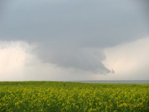
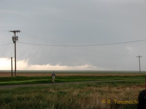
Wall cloud over broccoli fields near Victory, OK
Pained to have missed a tornado at our home base, we instead intercepted our target storm near Victory, OK, just west of Altus. It struggled with outflow contamination from the morning’s convection, producing only a brief wall cloud over blooming broccoli fields. As it merged with another cell to its northeast, the complex began to transition into an HP supercell. Nothing prevents an HP supercell from producing tornadoes, but they tend to be difficult to see. We decided to let the Victory storm head on its merry way.

Howie Bluestein, storm chaser
We took another jog west to intercept a developing storm between Gould and Hollis, OK, that we thought would have access to uncontaminated inflow with better moisture. However, the Hollis storm didn’t look much better visually, and in the meantime, the earlier Victory storm had grown upscale and was leaving a trail of tornado reports in its wake. Most of the reports mentioned that the tornado was rain-wrapped – not optimal for visual documentation. We opted to stick to our target storm, hoping against hope that it would tap into better moisture and warmer temperatures to its south, staying a few miles east of it as it “chased” us back to Altus. It produced this ominous shelf cloud over Gould:
Shelf cloud over Gould, OK on 13 April 2012

Daylight quickly faded, and we headed back to Norman just ahead of an MCS. I had forgotten to affix my new Pikepass sticker to my windshield, and the resulting 30-second delays while we aggregated quarters at each toll booth enabled the MCS to catch up, engulfing our car in blinding rain and dime-sized hail. Once back in Norman, we found large sections of town dark and surrounded by blinking Saf-T-Flares. The earlier tornado initially touched down near I-35 and Lindsey, then scraped northeast across downtown Norman, splitting trees, tossing sheet metal and demolishing a warehouse on Porter St. near the hospital. It was eventually rated EF-1 by the NWS.

Leave a Reply

Your email address will not be published. Required fields are marked *

This site uses Akismet to reduce spam. Learn how your comment data is processed.