Wednesday’s non-chase consisted of me looking up from my son’s bowl of mac and cheese, and seeing a tornado out the window. Okay, there was a little more to it than that. But lately, the storms have considerately come to me when I can’t chase. It’s one of the reasons I live in Norman!
I was aware of the SPC’s moderate risk for severe weather, but I had all but dismissed the tornado risk based on the crashing cold front setup. That setup had burned me too many times in the past. I’ve driven hundreds of miles just to watch nascent storms wither as a relentless southward surge of cold air sliced the legs out from beneath them, leaving me low and gas and without much to show for it. Instead, Wednesday’s storms latched onto the front and rode it south and east. We followed coverage on a couple of the local news networks, watching with rapt fascination as a storm that appeared postfrontal and undercut produced a 30-second funnel cloud near El Reno, OK.
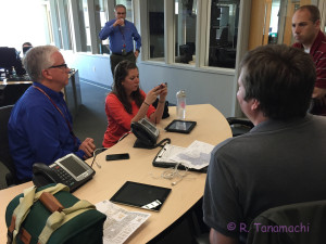
As the damage reports filtered in, and the complexity of the situation became clear, I felt inspired to email some people in the know about participating in the damage survey the next day. It may come as a surprise to some that I’ve never actually participated in a tornado damage survey before. I resolved this year that I would assist in at least one in order to learn firsthand, from the experts, how it was done. By the next morning, I had an invitation. Doug Speheger of the Norman NWS-WFO was gracious enough to let me join his team as they surveyed part of the preliminary track. Rick Smith, the WCM for Norman, tasked us with characterizing the event and focusing in directionality of wind damage indicators (DIs). Signals of a mixed-mode (tornado / straight-line wind) event were already evident in video and reports from the day before.
Getting ready to head out & do damage survey for @NWSNorman . Dividing up the preliminary damage track. pic.twitter.com/hjpb1GEQwE
— Robin Tanamachi (@tornatrix) March 26, 2015
I was worried that I might not have the training necessary to contribute to the survey, but instead of clipboards and cameras, we went into the field armed with a pair of iPads. The NWS uses a newbie-friendly, menu-driven app called the Damage Assessment Toolkit (DAT). We snapped pictures of damage, characterized the structures, typed in our comments, and uploaded the data points over the network to the NWS. Rick Smith said it was fun tracking our progress, watching as our data points gradually mapped out the track on screens back in the Norman office.
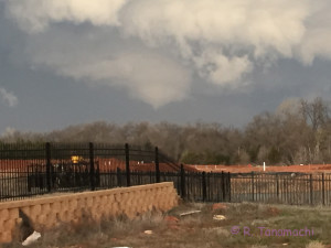
As we initially drove through the neighborhood northwest of I-35 and 4th St. around 9 a.m., I was surprised by how much cleanup had already been done. The streets were already clear and passable. Piles of branches and shingles had already been hauled to curbs, and some of those piles disappeared over the course of the survey. A handful of heavily damaged houses were marked with a bright orange “X,” indicating that the search-and-rescue teams had paid a visit. Workers were actively moving large, heavy debris out of yards and driveways even as we went door to door. We were actually in a race against time to document the “raw” damage before it was cleaned up.
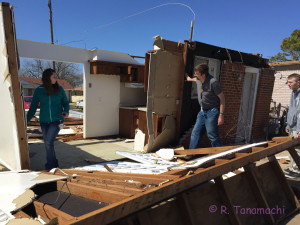
Most interesting find so far: 1/4 of roof missing from a house; we found it embedded in another house 2 blks away. pic.twitter.com/kQySLtXGL0
— Robin Tanamachi (@tornatrix) March 26, 2015
It was difficult to differentiate the wind and tornado damage in some areas. For the most part, the winds had moved debris from west to east. We found a few small zones (about half a block in size) where the damage was relatively intense, and clearly convergent. My impression was that we were dealing with a wide swath of mostly straight-line wind damage, with a few small tornadic spinups lasting only a few seconds. A few structures would need to be examined in greater detail.
340pm – survey teams confirm at least EF1 tornado damage in OKC/Moore. Multiple brief, weak tornadoes. We do not have a count as of now.
— NWS Norman (@NWSNorman) March 26, 2015
We will continue to piece together survey data. Complex situation. Large area of straight line winds with embedded small tornadoes. #okwx
— NWS Norman (@NWSNorman) March 26, 2015
Thanks again to the NWS office in Norman for letting me help make the news!
Edit: Thanks to Doug Speheger for correcting the my interpretation of the “orange X” markings.
Update, 3/30/2015: After some spot-checking of a few structures and a follow-up meeting on 30 March 2015, it was decided to upgrade the house at 2nd & Arnold, as well as a few others, to EF2. NWS-Norman released this damage contour map that afternoon:

Note that this map is still preliminary and could change further!
Update, 4/3/2015: Jim LaDue, another damage survey participant with much more experience than I, conveys his detailed thoughts on this event here.