All posts by tornatrix

2012-04-14: Tornadofest in Northwest Oklahoma

Today, I broke my personal record for the number of tornadoes seen in a single day (9, 10, or 11). Two were small funnels near Freedom, OK; the remainder were produced by a single supercell that we followed from Mooreland to Manchester, OK.

SPC 1630 UTC Day 1 Convective Outlook on 14 April 2012
SPC 1630 UTC Day 1 Convective Outlook on 14 April 2012. Copyright NOAA.
I had some trepidation heading out on 14 April because it was a widely-publicized SPC high risk on a Saturday. I had no wish to re-experience the Kingfisher, OK Charlie Foxtrot of 19 May 2010 (when it seemed like every storm chaser on the Great Plains converged on one two-lane highway, with a solid line of cars from horizon to horizon – not even joking). However, the moderate risk area stretched from the Missouri River to the Red River, encompassing Nebraska, Kansas, and most of Oklahoma, so I figured the atmospheric playground would be big enough to handle the chaser convergence. We decided to target the Oklahoma portion of the high risk, where the moisture was better and supercell shear was forecast. With the storm motions progged to be 35 mph or faster, our strategy was to follow tail-end Charlie storms until they raced northeast out of our reach, then turn back southwest to catch the next in line.

Our mini-caravan consisted of two cars: Jeff S., Howie B., and John L. in the first, while I drove Dan D. and Michael H. in the second. We departed Norman just after noon and drove up the Northwest Passage. From Seiling, we headed north on U.S. Hwy. 281, then west on U.S. Hwy. 412 after the first tail-end Charlie storm. Near Freedom, OK, we caught a glimpse of a slender needle funnel as we crossed the OK-50 bridge over the Cimarron River around 4:30 p.m. About 10 minutes later, just east of Freedom, it again produced a slender needle, both of which we captured on video. We were a bit disappointed at the brevity of both tornadoes; neither lasted more than 30 s. Knowing that a new storm was forming down the line, we decided to end round #1 and head back southwest toward Woodward.

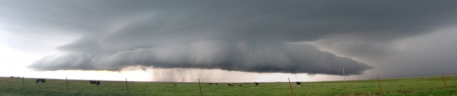
Back on U.S. Hwy. 412, we stopped about halfway between Moreland and Woodward. A second supercell with a vigorously rotating wall cloud churned past us just a few miles to our west, but did not produce any funnels. We followed that storm east along 412 almost to the intersection with U.S. Hwy. 281, where we decided to head south a mile or so and find an unobstructed view towards the next storm erupting back to our southwest. We staked out a claim on a pull-off near the top of a hill, and waited. Several other chasers joined us there.

2012-04-14: Woodward Co., OK tornado
2012-04-14: Woodward Co., OK tornado around 7:00 p.m. The view is toward the west.
Around 7:00 p.m., excitement began to build as the target storm grew near and a fat funnel descended about 10 mi to our west, playfully twirling a cloud of dirt at its base. That tornado had a lengthy (<15 min) rope-out phase as we trained our cameras on a new mesocyclone to its east, which also dropped a truncated funnel halfway to the ground to our NNW. We were elated to finally see some tornadoes with decent longevity and contrast, and we couldn't tear ourselves away. By the time we finally did pile back into our vehicles and headed back north on 281, yet another new meso was taking shape directly to our north. With the storm scurrying away toward the northeast, we were considerably behind it for the remainder of the chase. The new lowering narrowed almost to a square. The lower portion then tapered into an unequivocal funnel, and tornado #5 was born. Returning to the U.S. 412/281 intersection, we found that 281 northbound toward Waynoka was blocked by two police cruisers, forcing us to turn east. The chaser crowds had by then thickened considerably, and I focused my eyes on the eastbound shoulder of U.S. Hwy. 412, only stealing occasional glimpses toward the north, where Tornado #5 was churning happily away. (I trust that my husband got HD video for me to enjoy later.)

At some point, we stopped to film again, and I witnessed a bizarre handoff between two tornadoes. (It occurs at about the 3:00 minute mark in the YouTube video above.) One vortex eroded as another descended right next to it. We can be heard disagreeing verbally about whether we were witnessing multiple vortices within the same tornado revolving around a common center, or two separate tornadoes doing a graceful dance. (Mobile radar data could have settled that question, but unfortunately, RaXPol was in the shop.)

We then drove up OK-8 towards Cherokee, OK, with tornadoes (sometimes multiple tornadoes) visible almost all the way there. On our approach to Cherokee at around 8 p.m., I shot my first-ever 3D footage of a tornado with my new Bloggie pocketcam, and was pleasantly surprised by how well it turned out. (I’ll review the camera later.)

Tornadoes continued to snake out of the storm as darkness descended. As the driver of my vehicle, I had to keep my eyes on the road rather than the tornadoes, and I didn’t particularly care about an accurate count. I was simply enjoying sharing the spectacle with my passengers.

Our chase was ended by downed power lines just after dusk, a few hundred feet north of the Kansas border near Manchester, OK. There was still an unmistakable, lightning-illuminated funnel visible to our northeast. That tornado later triggered a tornado emergency for Conway Springs, KS, southwest of Wichita, but thankfully dissipated before reaching town. We made our way back to Norman by way of Enid, OK.

After midnight, as we straggled back into Norman, word began to filter through that a tornado, spawned from a trailing line of storms, had ravaged parts of Woodward, OK. Woodward suffered greatly at the hands of an F-5 tornado in 1947, an event that still figures prominently in Oklahoma lore. Unfortunately, six fatalities resulted, and cleanup and recovery efforts are still ongoing as of this writing. Donations for the victims can be made to the American Red Cross.

West coast shout-out

I was interviewed about my tornado research for Shan Boggs’s blog Interesting People. Mrs. Boggs specializes in science journalism, and she was a pleasure to work with. She previously interviewed my classmate and colleague Dr. Matt Haugland about microclimates.

The radar data graphic included in the blog is actually a figure that was cut from our recently-accepted MWR article, showing the vertical extent of the WEH associated with the 2007 Greensburg, Kansas tornado. Since I spent a few hours putting it together, I’m glad it finally saw the light of day somewhere!

Shelf cloud over Gould, OK on 13 April 2012

2012-04-13: HP supercells in Southwest Oklahoma

Altus, OK was our initial target. As I merged onto I-44 W from Hwy. 9 with Dan D., Jana H., Jeff S., and Howie B., we saw a disorganized storm roiling over Chickasha, OK. Thinking little of it, we blew on past, targeting the a much better-looking storm down the line near Snyder, OK, and later, yet another storm west of Altus. As we approached Altus on U.S. Hwy. 62, our phones began beeping with robotexts from OU: “Emergency: Tornado approaching. Seek immediate shelter indoors.” Pulling up the radar, we saw that the storm we had blown off earlier had developed a healthy hook echo as it approached Blanchard, and tornado reports were popping up across Norman from credible Spotter Network witnesses.

Wall cloud over broccoli fields near Victory, OK
Pained to have missed a tornado at our home base, we instead intercepted our target storm near Victory, OK, just west of Altus. It struggled with outflow contamination from the morning’s convection, producing only a brief wall cloud over blooming broccoli fields. As it merged with another cell to its northeast, the complex began to transition into an HP supercell. Nothing prevents an HP supercell from producing tornadoes, but they tend to be difficult to see. We decided to let the Victory storm head on its merry way.

Howie Bluestein, storm chaser
We took another jog west to intercept a developing storm between Gould and Hollis, OK, that we thought would have access to uncontaminated inflow with better moisture. However, the Hollis storm didn’t look much better visually, and in the meantime, the earlier Victory storm had grown upscale and was leaving a trail of tornado reports in its wake. Most of the reports mentioned that the tornado was rain-wrapped – not optimal for visual documentation. We opted to stick to our target storm, hoping against hope that it would tap into better moisture and warmer temperatures to its south, staying a few miles east of it as it “chased” us back to Altus. It produced this ominous shelf cloud over Gould:
Shelf cloud over Gould, OK on 13 April 2012

Daylight quickly faded, and we headed back to Norman just ahead of an MCS. I had forgotten to affix my new Pikepass sticker to my windshield, and the resulting 30-second delays while we aggregated quarters at each toll booth enabled the MCS to catch up, engulfing our car in blinding rain and dime-sized hail. Once back in Norman, we found large sections of town dark and surrounded by blinking Saf-T-Flares. The earlier tornado initially touched down near I-35 and Lindsey, then scraped northeast across downtown Norman, splitting trees, tossing sheet metal and demolishing a warehouse on Porter St. near the hospital. It was eventually rated EF-1 by the NWS.

2012-04-12: Bust in Canadian, TX

Dan D., Jeff S., Mike F., and I headed west on 12 April 2012. SPC had issued probabilities for severe storms from the triple point in W KS down the dryline into the TX and OK panhandles. The discussion mentioned the conditional nature of the severe storm potential; i.e., if storms formed, then they would likely be severe and have a good chance at producing tornadoes.

We initially drove up the northwest passage. We had a shot at targeting the triple point, but opted for the dryline bulge target in TX instead, heading west out of Watonga. The entire drive, we were socked in by low-level cloud cover – not a good sign, since it would limit solar heating and limit the ability of updrafts to punch through the moderately strong cap. It was also relatively chilly for a chase day – temperatures did not rise out of the 60s for most of the day.

Cumulus patheticus south of Canadian, TX on 12 April 2012
We set up shop in Canadian, TX, where the skies were clearing out, waited, waited, … and waited. Our eyes scanned the horizon for any sign of turkey towers. When one finally did erupt to our south around 7 p.m., we had nothing better to do, so we dropped south after it. A few bubbling cumulus clouds did develop, but none hit the tropopause, we ended up shower-chasing. We ended the chase in Elk City, where we enjoyed a decent supper at the Portobello Grill.

It was a high risk, high-reward situation, and unfortunately our numbers did not come up. In hindsight, at my own peril I opted to ignore a preponderance of model solutions that forecast a cap bust. As they say, however, if you don’t play, you can’t win.

Inaccurate reporting of SPC products

Hari Sreenivasan reporting on the 14 May 2012 tornado outbreak
Hari Sreenivasan reporting on the 14 May 2012 tornado outbreak on the 16 April PBS Newshour.
I’m still working on my chase logs for the last few days (some video is already up on my YouTube channel), but I wanted to sound off about two inaccurate information nuggets I keep hearing in media reports of this past weekend’s tornado outbreak, including, unfortunately, on the PBS NewsHour, a broadcast I respect greatly.

1. I keep hearing the number “120 tornadoes” bandied about as though it were an official tornado count. I presume this statistic was gleaned from the preliminary SPC storm reports page for 14 April 2012. The problems lie with the words “preliminary” (self-explanatory) and “reports”, many of which may be redundant and still have to be reconciled. If there’s a burglary, and three people call the police to report it, you don’t count it as three burglaries! (Update: The most recent updated count from Greg Carbin is 60, meaning there were an average of two reports per tornado.)

2. A number of reports have cited NWS for giving “warning 24 hours in advance”. A 24-hour lead time on a tornado warning is simply not possible at present. The SPC did issue a High Risk Convective Outlook more than 24 hours in advance, but not a watch, and certainly not a warning.

That said, the media have done a decent job giving credit to the NWS for being on the ball with this outbreak. Bravo, NWS!

Another, more complete perspective on this topic can be found here.

First chases of 2012

Southbound on I-35 after three straight days of chasing. The first two days (April 12 and 13) were busts. However, April 14 made up for them; I saw at least seven tornadoes today of all strengths, shapes, and sizes. I really need sleep tonight, but I can’t wait to make slew of photo- and video-laden postings tomorrow.

Dallas tornadoes have a lesson for chasers

Just after lunchtime yesterday, I was transfixed (as were many in the NWC) by live video of tornadoes near the Dallas-Ft. Worth metroplex. I did not chase yesterday because (a) it was a work day and (b) every time I’ve tried to chase in the DFW metroplex, it’s been a spectacular failure ending in traffic gridlock. But the supercells riding the warm front meant business. I’ve heard enough nightmare scenarios about a DFW tornado strike from the emergency management community to pass my hand over my brow and be grateful that nobody was killed.

Anyway, I’ve been fascinated by this now-famous video – shot from a helicopter – of the tornado flinging tractor-trailer rigs (or “articulated lorries”, as the BBC calls them) through the air near Lancaster, TX. I don’t know how much these rigs weigh or whether they were empty or full, but I think it’s safe to say that they weigh more than my little Corolla, a substantial SUV, or a pickup truck. I hope some of the “yahoos” watch this video and remember it the next time they consider brazenly driving into tornadoes as though they were little more than glorified dust devils.

Tornado Alley (the IMAX film) arrives in Oklahoma at last

RaXPol demo at the OKC Science Museum
Here, I introduce visitors to the RaXPol radar during a public outreach event at the Oklahoma City Science Museum.
Last weekend, I took part in an outreach event for the opening of the IMAX film Tornado Alley at the Oklahoma Science Museum. RaXPol’s caretakers kindly put me on the insurance for one day so that I could drive it up to the east side of Oklahoma City and back. I was charged with standing next to a radar truck I’d never used, to promote a film I hadn’t seen yet. I had some compunctions about that arrangement, but we were promised a free screening in exchange, so I decided to go for it. (I probably would have seen the film eventually anyway, at my own expense.) I always enjoy a chance to show off my “woman-in-science” cred, especially to a crowd that I knew would include lots of kids.

Mobile mesonet, field command vehicle, and radar trucks parked outside the OKC Science Museum.
Ironically, Tornado Alley only recently came to the Oklahoma market, despite being released over a year ago and featuring many Oklahoma “talents.” I tried in vain to see it in other cities during my travels, but was always thwarted by logistical impediments. That morning, the Science Museum staff kindly waved me and the other volunteers through the door into the 10 a.m. showing, free of charge. Don Burgess and Terra Thompson gave a brief introduction to the film before the lights went down. At the end, they did a Q & A, while we resumed our posts by our respective trucks, ready to answer questions. I parked down at the far end of the line, so I asked David B. to spin the RaXPol antenna periodically to draw people down my way. Former officemate Jeff S. joined me for part of the afternoon to help answer questions and talk about some of the data he collected in the 24 May 2011 tornadoes. And questions were plentiful; we had steady foot traffic of all ages, all day long.

Tornado Alley Poster at the OKC Science Museum
Tornado Alley Poster
Here’s my review of the film.

Tornado Alley is billed as Sean Casey’s magnum opus, the culmination of eight years of film-gathering in his Tornado Intercept Vehicle (“the TIV”). The film was partially sponsored by the National Science Foundation, who also sponsored VORTEX2. In the film, VORTEX2 mainly serves to provide a parallel story to that of the TIV crew, and that story is heavily CSWR-centric.*

Starting with the whale’s mouth swallowing the audience at the opening, Tornado Alley delivers the spectacular visuals that I’ve come to expect from IMAX. The filmmakers pack plenty of “torn porn” into 45 minutes. We see every frame of tornado footage they’ve got, and happily, they let the audience soak it in for 10-15 rapturous seconds before cutting back to the story. There’s a shot of a multi-vortex tornado that, in and of itself, is worth the price of admission. The IMAX format comes closest to capturing the all-encompassing experience of seeing a real tornado, minus the hours of driving, the bad food, and lightning danger.

Tornadoes with TIV near Stockton, KS, 2005
A frame grab from my video, taken near Stockton, KS, 9 June 2005. Two tornadoes, one light (left) and one dark (right, behind the white sign) can be seen in the background. Sean's head is sticking up out of the TIV's front "sunroof" as it turns left onto the gravel road. The resulting shot is used in the IMAX film, but, confusingly, is implied to be a tornado from 2009.
However, the narrative is a mess. The filmmakers try to squish together eight years’ worth of footage on the TIV side to parallel two years’ worth on the VORTEX2 side. I spotted tornadoes from 2004 through 2008 being passed off as tornadoes from 2009 and 2010. Goshen Co., WY makes an appearance a few moments after the 9 June 2005 Stockton, KS twins. (I was there. I even have video of the TIV turning down the road from which they got their shot.)

With regards to the science, the film punches far below its weight, especially so considering that it’s an NSF-funded excursion. We get a few minutes’ explanation of how a supercell, and then a tornado, form. They don’t quite dumb it down to the clichéd, “cold air mass + warm air mass = tornado.” But it’s not much better than that, not to mention that the animations accompanying the explanations look relatively crude for 2011. There’s almost no attempt to tie this rudimentary understanding to the story. At one point, Bill Paxton announces, “Sean Casey has picked the wrong storm.” In my mind, I immediately cried out, “Okay, why is it the wrong storm?” But hungry minds like mine are left wanting. The narrative is so jumbled that I can’t figure out what day it actually was. I can’t even go back into my own chase logs and look it up.

The climax of the film is supposed to be Sean Casey capturing IMAX film from inside a tornado. “The Shot” turns out to be a bit of a let-down, but I can’t say I was surprised. Every serendipitous film or video I’ve seen from inside a tornado has shown blinding rain, flying leaves and branches, and not much else. There’s no glorious, Twister-esque view up the tornado’s throat, no choral accompaniment, no dancing lightning bolts, no maelstrom of recognizable debris. I left as convinced as ever that there’s no point, visually, to driving into a tornado, because there’s nothing to see there. (In fact, I’m starting to think that Mr. Will Keller may have been full of it.)

To sum up, Tornado Alley contains a few truly delectable tornado morsels. But at the end of the film, I felt like I’d eaten a single buffet plate, not a three-course meal.

*Just in case you’re wondering: I’m not in it. The IMAX crew took one shot of my team in hurry-up-and-wait mode at a park in Kimball, NE, in 2010, but that shot didn’t make the final cut. The big group drive-by shot also cuts in just after Team Howie is out of frame. Drat!

New pub

I am a co-author on a paper in this month’s issue of Monthly Weather Review, entitled Impact of the Environmental Low-Level Wind Profile on Ensemble Forecasts of the 4 May 2007 Greensburg, Kansas, Tornadic Storm and Associated Mesocyclones. Dan ran a set of NCOMMAS ensemble forecasts of the Greensburg storm, assimilating reflectivity and velocity data from the Dodge City, Kansas WSR-88D (KDDC). He varied both the 0-3 km AGL velocity profile in the initial model environment to reflect the onset of a low-level jet, and also cut loose forecasts at different times to see how the vorticity swaths changed. Not surprisingly, the forecasts are better when the lead time decreases. However, there are still issues with the simulated Greensburg storm moving too quickly toward the east, possibly as a consequence of cold pool buildup.

We consider this paper a proof-of-concept study in support of the Warn-on-Forecast project. It demonstrates probabilistic forecasting of a tornadic mesocyclone’s track using operationally available data, albeit not in a real-time framework.

My contributions to this study were the dealiased KDDC data, the low-level VAD wind profiles, some of the graphics, and of course, help with the writing. (Fortunately, Dan is a good writer and didn’t need much help!)

One minor erratum – I just noticed that my listed affiliation is partly incorrect. I do work for CAPS, but my previous affiliation was CIMMS, not NWC. That’s an “oops” that I should have caught during the editing process. Fortunately, it doesn’t impact the science!

The “no warning” libel

It happens without fail every year, sometimes several times a year. The world learns that a tornado has ravaged part of America, and it wants to hear more details about what transpired. Reporters swarm in, armed with colorful digit-bearing microphones, and ply the locals for their stories of heartbreak and heroism. Words and images are collected, spliced, and reassembled. A maelstrom of pallid, shell-shocked residents, insulation imitating Spanish moss, and neighbors embracing among splintered homes are beamed to orbiting satellites from dishes.

Whenever I sense one of these pieces is about to air on the evening news, I grit my teeth, as do many of my colleagues. Here it comes…

“There was no warning.”

It’s happened more times than I can count. Reporters seem to go out of their way to find someone, anyone, who claims to have had no warning. And often, they succeed. People gathering up scattered possessions in the wreckage of their homes and lives appear to blurt out, “We had no warning,” as though on cue.

It happened yesterday. During the overnight hours of 22 January, a tornado outbreak impacted “Dixie Alley” in the southeast U.S., and horribly, two fatalities were confirmed. The outbreak occurred overnight, compounding the difficulties in disseminating warnings. The following evening, Dianne Sawyer led off the ABC World News cast thusly:

“Something terrifying took the South by surprise last night. No warning. Twenty-five tornadoes striking in less than 24 hours, roaring through four states in the darkness. And this was the scene today in Alabama, Arkansas, Mississippi, and Tennessee, where entire neighborhoods were wiped out as families slept. At least two are dead, one hundred injured.”

“No warning” is such a familiar refrain, it’s practically a joke. Granted, we meteorologists are accustomed to being the butt of jokes. But “no warning” is worse than a tired tagline or an injurious cliché. It’s a libel that impugns the reputations of my colleagues in the National Weather Service (NWS).

Libel is not too strong a word, because in most instances, a claim of “no warning” (i.e., zero or negative lead time) is unequivocally false. For starters, look at the archived products from the Storm Prediction Center for 22 January 2012. Every Day 1 Convective Outlook issued from 1200 UTC (6:00 a.m. CST) on contains a moderate risk over the outbreak region, the second-highest category of risk and “tornado” appears in the discussion. Tornado watch boxes, many of which were tagged “PDS” (particularly dangerous situation), popped up across the region as early as 5:20 p.m. CST, hours before residents went to bed.

But those are large-scale outlooks spanning several states. What about warnings? The NWS office in Little Rock, AR issued 12 tornado warnings on 23 January (UTC time). The Birmingham, AL office issued 16. The list goes on. Informal accounts from colleagues within the NWS indicate that many of the tornadoes had 20 or more minutes of warning lead time. (The mean lead time for a tornado warning currently stands at 9.5 minutes; Simmons and Sutter 2005.) NWS personnel have no cause to lie or exaggerate on this point, because the warnings, watches, and discussions are all a matter of permanent public record.

But death sells. People die in a tornado, and survivors ask, “Why?” Is anyone to blame when such a violent, seemingly random act of atmospheric violence steals or maims a loved one? Appearing to malign the victims is not an option, even when, by all accounts, the victims are unable, unwilling, or simply too disengaged to even be cognizant of imminent danger. Neither is laying the blame on supernatural powers (for fear of rousing the ire of nonbelieving viewers) or pure chance (which it is not). Who’s left? The organization mandated to issue timely and accurate weather forecasts and alerts to the public: the NWS. NWS personnel are likely to be tied up in the immediate aftermath doing damage surveys and service assessments, and perhaps less likely to respond to such criticisms. So, falling back on the “No Warning” tag line is a safe choice. The viewer is left in a “No Warning” echo chamber. Outrage builds. Legislators demand answers. Something Must Be Done. Despite having carried out their duty to the best of their ability, NWS’s reputation can only erode in the face of such repeated, inaccurate reporting.

The NWS is not a faceless government entity. Flesh-and-blood-human forecasters and support staff work there 24 hours a day, 365 days a year, in largely invisible service to millions of people who will probably never thank them. I know a handful of these forecasters, many of them former classmates. Without exception, they are passionate about their work, despite meager pay, grueling hours, and routinely having to endure slings and arrows of misinformed public opinion.

As a consumer, I challenge ABC to publicly correct the erroneous “No Warning” newscast from 23 January. I would also like to challenge members of the media to verify claims of “no warning” before they are repeated in a national broadcast. Call the NWS office responsible. If you can’t get an answer, query databases of severe thunderstorm and tornado warnings. Here’s one from the University of Iowa that takes only a few seconds to search. (Hint: the prefix for a tornado warning is “TOR”, Ctrl+F will get you a quick count.)

What alternative tack would I suggest? There were other likely contributing factors to the 22 January fatalities that could serve as a starting point for inquiries. For example, residents may not have been as tuned in to the weather as they would have been during the typical “Dixie Alley” storm season (roughly March through May). Nocturnal tornadoes are known to be a disproportionate source of tornado fatalities, because they catch victims in a diminished state of awareness (Ashley et al. 2008).

Remember that viewers at home are the other end of the weather information conduit. If they’re tuned out, all the warnings in the world won’t make one iota of difference. Hook viewers in and empower them with accurate weather safety information well in advance of storm season. Showcase weather radio and publicize severe weather preparedness events every year. Eventually, the defamation of “no warning” will ring as hollow as it truly is, and be replaced by, “Everyone did everything they possibly could have.”

References:
Ashley, Walker S., Andrew J. Krmenec, Rick Schwantes, 2008: Vulnerability due to Nocturnal Tornadoes. Wea. Forecasting, 23, 795–807.
Simmons, Kevin M., Daniel Sutter, 2005: WSR-88D Radar, Tornado Warnings, and Tornado Casualties. Wea. Forecasting, 20, 301–310.